The sky was a hazy, blue color with a temperature of 62 degrees, but it was windy. The sky further to the north had a grayer haze to it. Traffic was light and after going 45 minutes the sky to the west became very dark. Rain was now coming my way. I continued to drive north through some areas where it had recently rained as the pavement was wet in front of me. It was raining in Hinckley when I got there. The temperature had dropped to 54 degrees.
It continued to rain on and off as I made my way north toward Duluth. I decided to call Char at the Isabella Work Station to see if she or someone else was going to be there when I arrived in the afternoon or if I would need to drive to Tofte to pick up my permit.
I arrived in Duluth at 1002 am. Last year I stopped at the Duluth Pack Store and shopped for 10 whole minutes. Let’s see how long I’m in there this year. I stayed a half hour. I was fortunate to be able to park on the street near the store. Someone was just pulling out of a parking spot when I arrived.

 Usually when I stop in the store I buy some books. It was no different this time. I bought the new edition of the Snow Walker’s Companion by Garrett and Alexandra Conover and Indian Creek Chronicles by Peter Fromm.
When I got to Illgen Falls on the Baptism River I decided to stop and take a few photos of the falls. I made a few more stops along Highway One as I made my way to Isabella. I got to the Isabella Work Station at 1pm.


I stopped in at the warehouses in back of the compound. This one warehouse has now been turned into an office where they issue permits and an employee work area. I talked with Char who I have spoken to a couple times over the phone recently. I told her I used to work out of Isabella in the early 1980’s when it was the Ranger Station. I asked her about a couple of people who I knew back then.
 During the drive up this morning I was trying to determine what I should actually do on this trip. The wind had been blowing very hard the entire drive up to Isabella. I’ve tentatively planned to paddle the Island River today, and then I would bicycle over to Hog Creek tomorrow to begin my canoe trip.
When I worked for the US Forest Service I worked as a Recreation Technician. I patrolled the dispersed camping sites within the Isabella Ranger District. Sometimes I would drive a big loop to some of the different areas that I would check during the day. I wanted to travel this loop today, but if I did that it wouldn’t leave me much time to visit the pictographs on the Island River and return today.
My other concern was what the water level would be between Perent Lake and Isabella Lake. If it was low it would be real bony, but it doesn’t appear I’m going to have a problem after driving through the forest today and seeing the water in some of the streams that are usually dry or very low at this time of year.
Well, I made up my mind and made of change to my original plans. I got the last permit for Isabella Lake for tomorrow, Friday, 09-14-07, so I could drive the loop today. Tomorrow I would enter Isabella Lake and paddle to the east toward Ferne Lake. Depending on the wind!
When I left Char at the Isabella Work Station I drove to the Little Isabella Campground further up Highway One and changed into my paddling clothes. I walked to the Little Isabella River where I have done some Brook Trout fishing in the past. The creek had more water in it than I ever have seen in the past.

 Next I drove back through the town of Isabella to the dirt road that went east out of town. (Forest Road (FR) 172) When I worked for the Forest Service I knew this road being called the Dumbbell Lake Road. Maybe that was what all the Forest Service employees called it. Now I see a road sign and the sign says, “Wanless Road”. Back when I worked up here there were very few road signs. Most of them were the Forest Road number signs at the junctions on some of the main forest roads.
(While I’m writing in my journal at the parking lot of Isabella Lake, it’s 0837 pm and I just went in the tent because it started to rain)
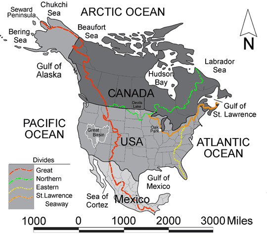
While I drove east down the Wanless Road I stopped at several places along the road to take a few photos before reaching Divide Lake. Divide Lake is about 5 miles east of Isabella on the Wanless Road. Divide Lake gets its name because it’s on the Laurentian Divide. The Laurentian Divide separates the watershed of rivers that flow north to the Arctic Ocean from the watershed of the rivers that flow southeast through the Great Lakes to the Atlantic Ocean. The Laurentian Divide is also known as the Northern Divide.
http://upload.wikimedia.org/wikipedia/commons/4/44/NorthAmericaDivides.gif

 I remember camping here several times in the past before all the upgrades to the campsites. There are now three pay sites to choose from to camp.
Around the lake is a rolling two mile hiking trail that I walked a short distance on to get a feel for it. The portion I walked was very easy walking with good footing. I recall fishing for Rainbow trout in this lake and Hogback Lake further to the east. Both of these lakes were designated trout lakes and were stocked with trout. I don’t believe the lakes are stocked any longer.
Next stop was Hogback Lake about 7 miles from Divide Lake on the same road. Years ago I had walked the trails around these lakes, but today I just looked over the area. There have been changes to this parking area.
I left Hogback Lake and turned left to go north on County Road 7 to continue around the loop. I’ve never been to Wye Lake when I worked here in the 80’s, but there is now a portage trail to the lake. Wye Lake is near the junction of Co. Rd 7 and FR 369. I knew FR 369 as the Sawbill Landing Road. I walked the portage down to the lake and saw some large white-caps waves on the lake.


 Afterwards I got back into my Suburban and continued on to Silver Island Lake. There is newer road to this lake now. This has always been a very popular fishing lake. That has to be the reason for this upgraded road to the lake.
 Now I was on my way to Section 29 Lake off of FR 356. The campsites here have been upgraded. There are two maybe three camping sites with an outhouse. This was another popular fishing lake when I worked up here.
 Instead of taking the forest roads the long way around to Isabella Lake from Section 29 Lake I jumped on the old railroad grade (FR 379) that would eventually parallel a portion of the Island River. It would come out about a mile south of Isabella Lake on the Tomahawk Rd (FR 377).

 Once I got to Isabella Lake I grabbed my camera and tripod. I walked the west portion of the Pow Wow Hiking Trail to the foot bridge that goes over the Isabella River. This area is to the west of Isabella Lake. The trail head has also been re routed. Now it starts in the parking lot. I used to access the hiking trail from off the Tomahawk Road. The first portion of the Pow Wow trail used to be an old logging road. The alders are now covering the roadway from both sides of the road. I remember in the spring of 1981 my supervisor at the time and I walked north along the trail. Then we continued on the trail when it turned to the west at the first junction. We were checking some of the side trails off this part of the trail. We were keeping our eyes open for the possibility of finding some moose antler sheds. There was still some patchy snow on the ground, when I found a moose antler that was in good shape. We began looking around the immediate area for the other shed. Not too far away, Terry, found the matching antler shed. I still have this antler to this day, almost twenty-eight years later.


 There were several cars parked in the Isabella Lake parking lot and all the BWCA permits for tomorrow are taken. There’s a campsite next to the Pow Wow trail on the west side of the portage that’s available in case I can’t find one tomorrow, depending on the wind direction. Isabella Lake is a fairly shallow lake so the waves on the lake can get quite large. I’ve seen some big waves on this lake in the past.
 It was time to make camp. I decide to camp in the parking lot instead of going elsewhere. The parking area is very large. I set up my tent and cooked some spaghetti. For dessert I made some pudding.
 After eating I walked the portage down to the lake. There really wasn’t anything too interesting to take any pictures of, but I took some anyways. It was getting dark out so I walked back up to the parking lot.


I looked at my watch when I got back to my tent and it was 0856 pm. I decided to get my maps out to see where I might head tomorrow.

Marvellous!
ReplyDelete